Posion yhteismetsä
10 products

 — Show original
SNOWMOBILE PERMIT FOR THE POSIO COMMON FOREST AREA, so-called Freeride permit:
NOTE! Permit description updated 18.2.2025
The Posio communal forest area has diverse landscapes for snowmobiling. The communal forest operates forestry in the area all year round and the area contains a variety of forests, from young saplings to old forests. There are many differences in altitude; the altitude above sea level varies between 125 and 375 meters.
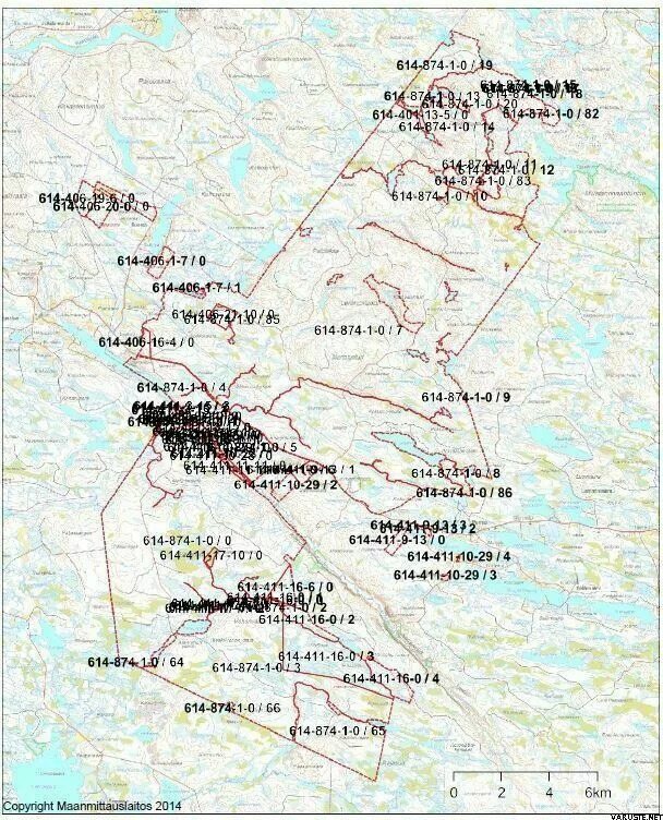
The permit area covers the Koro, Voho and Jumisko plots owned by the Posio joint forest cooperative, and their combined area is approximately 25,000 hectares. Please note that the permit area only covers the areas according to the registration number 614-874-1-0 in the map appendix.
Digital map data for driving areas is now available through the Mapitare map application. The Mapitare application can be downloaded for Android devices from the Play Store and for Apple devices from the App Store. The application can be found under the name: Mapitare Land and Sea Map . The basic license for the application costs €19.99/year.
The Mapitare system can also be expanded to include, for example, the location of riding companions/sleds using the Ranniot positioning system. For more information about Mapitare, visit: www.mapitare.fi and Ranniot: www.ranniot.fi .
Note! In addition to the no-driving zones in the digital map material, there may also be separate no-driving zones, the map attachments of which are available when purchasing a permit.
Posio yhteimestä primarily recommends purchasing the digital Mapitare application , which makes navigation in the terrain the easiest and makes advance planning of the driving trip easier, as prohibited driving areas such as saplings are shown in the application as open, uncolored areas. Allowed driving areas are shown in the map application with a bright green background color . Note! The Mapitare application may also show freeride areas of other yhteimestä forests with the same map theme, so make sure you are moving to the right driving area!
Note! Navigation with the Mapitare/Ranniot applications is also possible in offline mode, even if there is no mobile network and if the maps have been downloaded to the phone/tablet before moving outside the mobile network. You can see the freeride areas in the Mapitare application by activating the "sled routes" map layer.
In addition, Posio yhteimestä sells a paper recreation map printed at a scale of 1:30,000 for 15.00 euros/piece. Paper maps can be requested from the yhteimestä office at Posiontie 44, 97900 Posio and from the Neste Oil Posio gas station at Uimaniementie 7, 97900 Posio. Maps can also be requested by email; markus.laatikainen@posionyhteimestä.fi or by phone at 040 1792110.
A PDF map of the permit area, a map of prohibited driving areas, and a safety document will be sent to the buyer upon order confirmation.
The driving area map is also available for download, for example, to the Tracker and Ultracom dog radar applications with the OmaRiista ID 457HLYXVQ5. The driving area is in accordance with the OmaRiista map, excluding the objects mentioned in the permit conditions, such as saplings. Note! The OmaRiista maps do not show prohibited/permitted driving areas, but they only work digitally in the Mapitare application, so we recommend purchasing Mapitare first.
In addition, sledding is prohibited, among other things, in the vicinity of holiday cottages, such as in Ala-Outojärvi, Poksamo and the Julmajärvi-Pyytölampi coastal site plan area, as well as in the vicinity of Lemmonlampi. Maintenance driving to the cottages and the Ala-Outojärvi lean-to is permitted. Please read the attached NO DRIVING AREA maps and follow the instructions! In addition to the no-driving areas, other permit instructions must be followed, as mentioned below (e.g. restrictions on saplings).
Outside the shared forest area, especially to the east of the Koro parcel, there are many nature reserves managed by Metsähallitus, including the Palotunturi area and the Pyytöuoma nature reserve, where sledding is strictly prohibited. In addition, there are nature reserves established in 2023 around Karhunpesälampi and Sitkaimenpalo in the shared forest area, where sledding is also prohibited (see the attached maps). Sledding in nature reserves and other unauthorized areas is subject to a fine. Familiarize yourself with the available map materials in advance and make sure that you are moving within the permitted area and in accordance with the permit conditions.
Special care must be taken when driving off-road in relation to trees and animals; for example, driving in saplings is strictly prohibited. Saplings are forests with young trees, with a tree length of less than 5 meters. Please note that young saplings may be below the surface of the snow, making them particularly susceptible to damage. Saplings, like other trees, are of great economic importance to the landowner, so respect the landowner's property.
The Murtotuuli wind farm will be completed in the permit area during 2022. The Murtotuuli wind farm
The wind farm is located in the Murto, Lemmon and Vitikkotunturi fells and Palokilka area and comprises
a total of 21 wind turbines. There may be occasional disturbances at the wind farm construction site.
construction site traffic, which must be taken into account when moving around the area or parking cars and
transport equipment. In addition, in the vicinity of wind turbines, within a radius of approximately 200 meters from the power plants, unnecessary movement and parking of transport equipment should not be allowed, as ice may fall from the power plants in winter. Possible ice falling from the power plant structures can cause damage, so moving or staying in their vicinity should be avoided. The wind turbine safety zone (200 m radius) is shown in the Mapitare/Ranniot map applications.
Contact information for the operator responsible for the wind farm: Taaleri Energia, Miika Sinettä, tel. 044 3181044.
A map of the wind turbine locations is included in the attached documents to this permit.
There are approximately 70 kilometers of marked, unofficial snowmobile trails in the Koro and Voho sections. In addition, with a permit, you can also ride outside the marked trails, but only if you do not cause damage to nature.
NOTE!
The public forest regularly monitors off-road traffic in its areas.
If damage to trees or saplings, for example, or other activities that violate the permit conditions are observed in the area due to sledding, the landowner may stop sledding in the area.
Remember that you are responsible for the continuity of your freeride activities!
It is strictly forbidden to chase reindeer and moose!
In the permit area, there are some randomly plowed roads and parking lots in the winter, which can be found on the “Parking lots” map attached to the permit. There are a total of four parking lots reserved for sledders in the Koro section and they are marked with traffic signs. Please note that the parking lot at the eastern end of Pyytölampi is reserved for cottagers in the Julmajärvi-Pyytölampi area, and no one other than cottagers may park there. The Pyytölampi parking lot in question is marked with traffic signs, which state that it is for cottager use – so read the traffic signs carefully! We aim to keep the beginning of Palojoentie, approximately 8.5 kilometers north of Rovaniementie to Kuovitunturi, open in winter. Note! Avoid sledding on snow banks on plowed roads – it makes plowing the roads significantly more difficult.
Do not block the road with cars/transportation equipment and ensure that cars/transportation equipment are parked safely and properly.
The permit area is located in a reindeer herding area, and no harm may be caused to reindeer herding.
Snowmobiling in a permit area is at the snowmobiler's own risk. If the snowmobiler's actions cause damage to the landowner or a third party, he or she is liable for damages.
If inappropriate behavior is observed in the permit area, the permit area can be closed if necessary and the sale of permits for the area can be terminated by decision of the landowner.
Unauthorized sledding is always reported to the police.
Considerations for public safety;
Please read the “Safety Document” attached to this permit carefully and follow its instructions!
THE GENERAL EMERGENCY NUMBER IS 112
Contact information for the employees of the public forest;
CEO Markus Laatikainen 040 1792110
Forestry expert Jyrki Pitkänen 040 8335136
INSTRUCTIONS FOR BUYING PERMITS
The driving license is in electronic format and will be sent to the email address provided. Always check the content of the order confirmation ( date, area and names of the license holders).
The order confirmation serves as a driving permit, so print it out and take it with you when you drive.
NOTE: Toboggan permits are only reserved after you have pressed the Submit Order button at checkout. If permits are sold out for the products in your shopping cart while you are preparing your order, the permits will not be purchased.
Please note that purchased permits cannot be returned, changed or exchanged. The name of the permit holder cannot be changed afterwards.